After a winter “wet season” that left much of California high and dry, a dramatic and very unusual early summer pattern change is unfolding over the Eastern Pacific that will bring significant rainfall to most of Northern California this week.
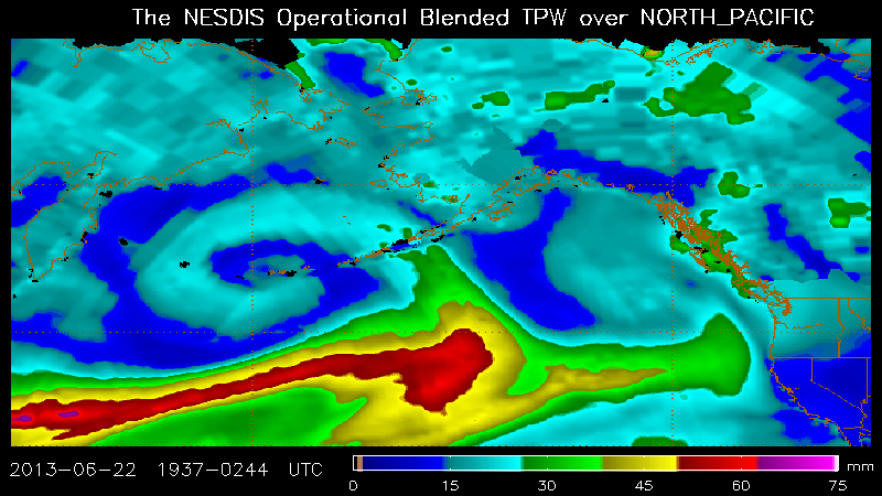
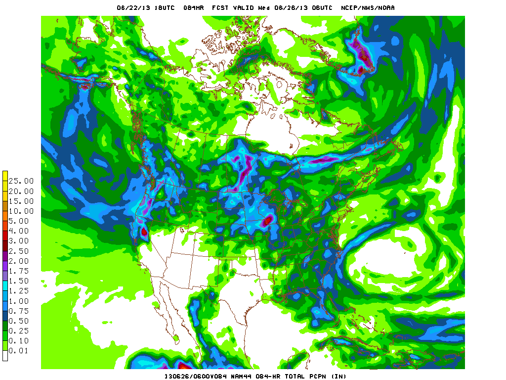
June rainfall in California, especially the northern part of the state, is not itself extremely unusual. But the current synoptic setup, combined with the amount of rain that may fall in some areas over the next few days, is likely to break some (decidedly low!) June rainfall records. An unseasonably deep low in the Gulf of Alaska is directing a rather strong jet stream towards the West Coast, and a handful of cyclonic disturbances are propagating within the mean flow. As the core of the jet sags south over Northern California, two rainfall-producing systems will move ashore, bringing widespread rainfall and possibly even some heavy rainfall in orographically favored regions. The numerical models have for several days been indicating that there will be a very deep moisture plume associated with this system–in fact, this plume likely qualifies as an “atmospheric river” given its highly anomalous precipitable water content (>1.5 inches). What does this mean in practical terms? Well, the second system (due in later on Monday) will almost certainly produce widespread rainfall, but there is some considerable uncertainty regarding the actual accumulations that can be expected. The NAM/GFS have been spitting out some very impressive rainfall totals for late June–in excess of 2-3 inches for some parts of NorCal (and more than 0.25 inches for most of the region). While the ECMWF and more recent GFS runs are slightly more conservative with precipitation estimates, these amounts are regardless very impressive for late June, and will likely break at least some daily rainfall records. Winds do not appear to be a major issue with this system, though the rainy/blustery conditions will feel decidedly more like November than almost-July for the early portion of next week.
The parent low in the Gulf of Alaska will only slowly retreat back to the north as the week progresses, though strong high pressure will build in from the southeast and bring much warmer and drier conditions by late in the week. There are some early hints that the remnants of an East Pacific tropical system could become entrained in the anomalous northward flow off the coast of CA driven by the persistent Gulf of Alaska low, but that potential is still over a week out. One thing that looks more certain, though, is that California is probably in for a pretty big heatwave after this week, as some GFS runs have been indicating 850mb temperatures of nearly 30C (!). Given the flow pattern, there are also some very early signs of an early monsoon or monsoon-like surge in the week 2 period.
So, in sum: it looks like the weather in California is going to be considerably more interesting than it usually is in late June. Stay tuned!
© 2013 WEATHER WEST
