Notable “parade of storms” continues over Eastern Pacific; heavy rainfall & some flooding across Northern California
In my last blog post, I discussed an imminent “parade of storms” that was slated to begin during the first week of the new year.
Over the past two weeks, a series of strong and moist storm systems have brought wet and occasionally hazardous weather conditions to different parts of the state. Two major low-latitude storm systems affected Southern California during the first week of January, bringing widespread heavy precipitation and flooding of varying severity. The most remarkable part of these early January systems, though, may have been the intense convective activity associated with them. Widespread thunderstorms–some of them severe–brought significant flash flooding, damaging winds, and even a couple of tornadoes. These two storms–characterized by ample atmospheric moisture, unusually high atmospheric instability, and excellent jet stream-level forcing–were highly reminiscent of the more memorable Southern California storm events during the 1982-1983 and 1997-1998 El Niño events.
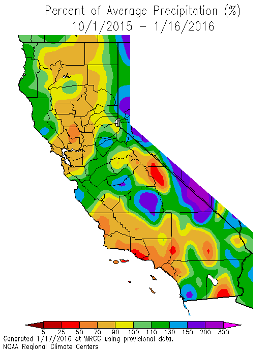
Since that time, Southern California has dried out considerably as the Pacific storm track shifted northward. But it hasn’t shifted nearly as far north as during recent drought winters–the Pacific firehose has instead been aimed squarely upon the northern half (and especially the northern third) of California in recent days. Impressive double-digit rainfall totals have already been observed, and still there is much more to come in the coming days.
In fact, several major North Coast rivers are currently approaching or exceeding flood stage, and sections of the Sacramento River may exceed flood stage as well over the next few days (in any case, the weirs will certainly be overflowing). Meanwhile, snow accumulations in the Sierra Nevada have been equally impressive, and are the best in years (110% of average to date, a number I expect to rise further this week). Right now, all of this water in Northern California is very good news. Enough precipitation is falling to generate significant runoff without greatly exceeding the capacity of river systems to manage the influx (most flooding to date has been relatively minor in NorCal). Conditions have been cool enough for this precipitation to fall as snow at the higher elevations, meaning that California’s critically important “snow reservoir” is starting to fill. There’s still a lot of empty space in Northern California’s man-made reservoirs and natural groundwater aquifers, but at the moment things are moving in the right direction from a drought relief perspective.
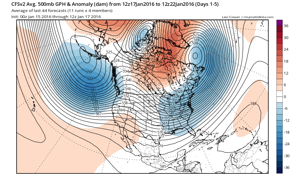
Strengthening and “straightening” Pacific jet stream, characteristic of strong El Niño events, now in place
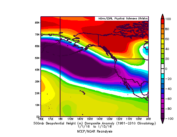
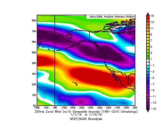
I’ve discussed on numerous occasions that the main mechanism by which El Niño affects California winter precipitation is by enhancing the subtropical jet stream over the far Eastern Pacific. As the jet strengthens and shifts southward, it effectively “straightens” out in the vicinity of California–reducing the amplitude of its typical northward bend that can often cause storms to veer northward into the Pacific Northwest or weaken before reaching California. This past autumn, an enhanced Pacific jet stream did indeed develop, but it was located well to the north of the Golden State (and brought record-breaking rains & floods to Seattle and Portland). Since the fall, though, this El Niño-strengthened jet has shifted gradually southward. The enhanced Pacific storm track is now consistently soaking Northern California, and bringing more transient soakings to Southern California. For reasons relating to the intrinsic seasonal cycle of the Pacific jet stream, I would expect unusually wet conditions to continue to expand southward along the California coast in the coming weeks. In fact, a quick glance at how upper-atmospheric conditions have changed since the autumn shows a striking transition towards a classic El Niño pattern over and west of California, with a roaring subtropical jet and a large negative geopotential height anomaly over the northeastern Pacific (yet more confirmation that the Ridiculously Resilient Ridge is outta here).
Yes, the southern third of California has thus far experienced below-average rainfall so far this season. But…
There continues to be much consternation regarding the fact that parts of Southern California remain well below-average precipitation-wise for the season to date. It is certainly understandable, after consecutive years of abysmal rain seasons, that drought-related anxieties are running high. And it’s interesting to note that one of the relatively driest spots in all of California so far this water year is Los Angeles County–which comprises a considerable fraction of the state’s population. But nearly all of California has fared better than Los Angeles County so far this season–and prospects for significant Southern California precipitation remain high in the coming weeks. It’s important to remember than California’s rainy season is relatively short and sharp (particularly in the south), and that the vast majority of precipitation falls over the course of a handful of heavy precipitation events (like, for example, the early January storms). Even during California’s wettest winters, most winter days are dry in Southern California–and multi-week dry spells occur virtually every winter. It’s also true that many of Southern California’s wettest seasons were primarily the result of only 1-2 very wet months. Thus, there is plenty of time for Southern California to catch up–and exceed–average precipitation this winter.
Pacific jet extension likely over next 1-2 weeks; enhanced precip should expand southward by end of January
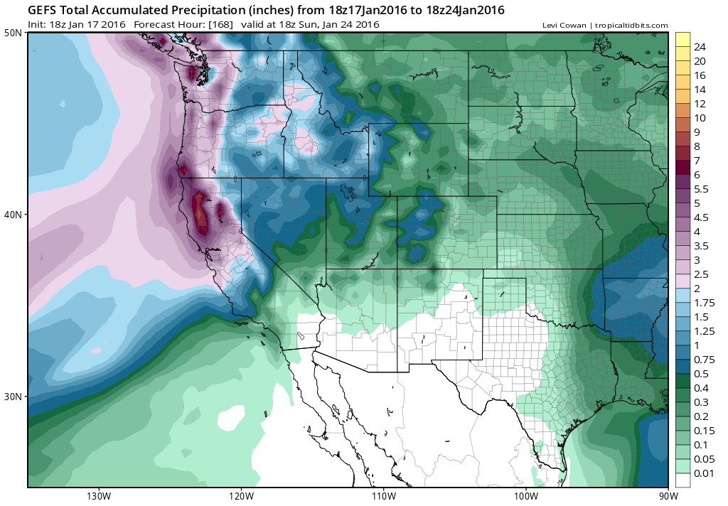
A lot more rain is in the forecast for Northern California over the coming 7-10 days (perhaps more than 10 or even 15 inches in orographically favored parts of the North State, and more than 6 inches in the coastal mountains as far south as the Bay Area). Then, during the final week of January, there is an emerging model ensemble consensus that an burst of jet stream energy from the West Pacific will propagate eastward across the entire basin, forcing the Pacific storm track southward from Northern California and bringing enhanced precipitation to the entire state. Such an active jet pattern makes pinpointing the details nearly impossible more than a few days in advance, but there are early signals of a situation potentially similar to the one we experienced in early January.
Flood concerns will grow across Northern California as soils are now completely saturated from days of heavy rainfall. With a substantial snowpack, any warm “Pineapple Express”-type storms could pose a risk of snowmelt-related flooding. If storms can remain relatively well spaced-out, it’s entirely possible major flooding may be avoided, and that the upcoming very wet period will be almost exclusively beneficial in a drought-stricken state. But California is no stranger to getting too much of a good thing, and the potential for that to occur is rapidly increasing as watersheds finally reach saturation capacity for the first time in several years.
Powerful El Niño still in place; maximum Southern California impacts likely still to come
Interestingly enough, our record/near-record strength El Niño event is not going away without a fight. In fact, one of the strongest westerly wind bursts on record–apparently exceeding most of those during the infamous 82-83/97-98 events–occurred just last week. While Nino 3.4 sea surface temperatures have likely reached their peak, very warm equatorial ocean temperatures may persist even longer than initially expected and will certainly continue for the rest of winter and likely most/all of spring. Further, El Niño’s impacts in California tend to lag peak ocean temperatures by a month or two. Thus, the rest of January through March (and perhaps even April or May) will be prime time for increasingly prominent El Niño effects–including a greatly enhanced subtropical jet stream and periods of enhanced storminess and heavy precipitation throughout California (yes, this includes Southern California). Stay tuned!
© 2016 WEATHER WEST
Discover more from Weather West
Subscribe to get the latest posts sent to your email.