The big picture: trends in the tropical Pacific Ocean
The tropical Pacific has taken a decidedly circuitous path over the past several years toward its present extraordinary warmth. Until 2014, persistent and increasingly anomalous warmth in the tropical West Pacific Ocean (near Indonesia) had been in place for the better part of two decades—not coincidentally since the last big El Niño event in 1997-1998.
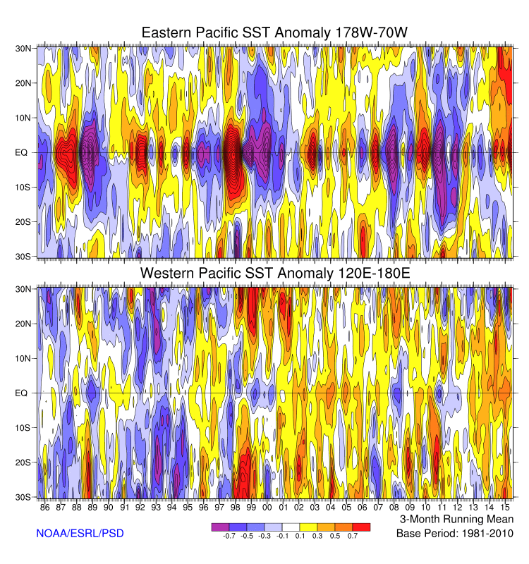
The tropical East Pacific, on the other hand, experienced no such net warming between 1998 and 2014. Since the tropical West Pacific is already warmer on average than the East, this trend led to a substantial increase in the west-to-east temperature differential across the Pacific Ocean basin over a 15 year period. This mean state change generally resembled the ocean temperature pattern associated with La Niña, and as a result the Pacific entered a persistent “La Niña-like” state after the 1997-1998 El Niño.
Since the tropical Pacific Ocean has a profound influence upon global climate, this relative warming of the West Pacific had substantial atmospheric effects around the world. The observed pattern of ocean temperature change created a propensity for drought in some regions around the globe—perhaps including California, which has been experiencing drought conditions more often than not over the past decade and a half. The relative warmth in the west and coolness in the east even had a detectable influence upon the Earth’s mean atmospheric temperature, as the planet warmed more slowly over this period than it otherwise would have due to global warming alone. A significant amount of this accumulated energy instead went into heating the world’s oceans—especially the tropical Pacific, where vast quantities of heat were sequestered in the West Pacific Warm Pool and adjacent Indian Ocean.
In early 2014, however, it became clear that something different was brewing in the tropical Pacific. Westerly wind bursts—which encourage warming of the ocean surface in the central and eastern Pacific, and which had been largely absent in recent years—started to increase in frequency and magnitude. Ocean and atmosphere models used to predict the evolution of the Earth’s climate in real-time started to suggest the potential for a major regime shift in the Pacific, with pronounced warming of the eastern Pacific. By early spring 2014, rumors of a strong El Niño event were flying—and were generally supported by model forecasts. But by early summer, the westerly wind bursts stopped rather abruptly, prematurely shutting down the complex chain of self-reinforcing feedbacks that need to be in place for an El Niño event to develop and fully mature. While modest warming of the tropical East Pacific did occur, the atmosphere never really responded to the oceanic changes in a meaningful way, and model forecasts by early summer quickly fell toward a borderline event, at best.
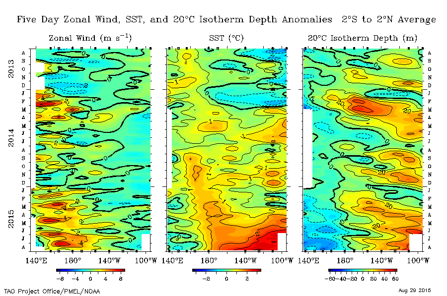
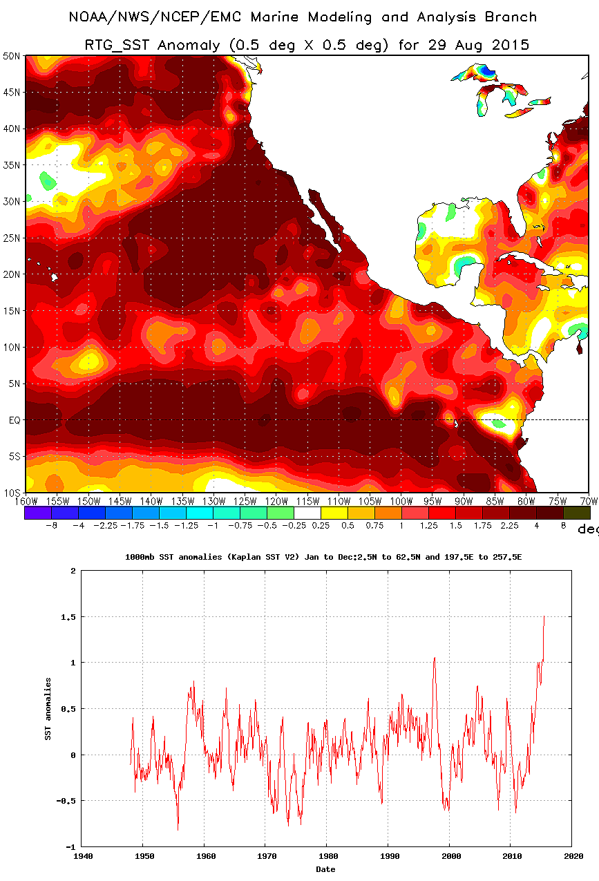
Early 2015 brought similar news, with several new bursts of westerly winds and corresponding model forecasts of a building El Niño. This time, however, the anomalous westerly winds did not abate. The East Pacific had already built up considerable tropical and extratropical warmth during the “non-El Niño” of 2014, and additional heat quickly accumulated through the spring and early summer months of 2015. Much unlike 2014, ocean-atmosphere model forecasts continued to grow more emphatic regarding the potential for a very significant El Niño event by late summer. And this time, they were right: warmth the eastern tropical Pacific has recently reached values only seen previously during the strongest El Niño on record in 1997-1998. The atmosphere, too, has gotten its act together this time around—and is exhibiting a more strongly El Niño-like circulation pattern than has ever been observed previously during the summer months. Nearly every record that exists regarding tropical cyclones in the tropical Pacific has been broken over the past six months—and as of this writing, 3 major hurricanes were churning simultaneously over the central and eastern Pacific for the first time in recorded history. In fact, the combination of a powerful El Niño event and the sudden re-emergence of accumulated heat from the tropical West Pacific has created unprecedented warmth over a vast expanse of ocean, stretching thousands of miles from coastal Peru to the Gulf of Alaska.
The forecast: persistence and further strengthening expected
We’re now long past the much-discussed “Spring Predictability Barrier,” and coupled ocean-atmosphere model forecasts remain nearly unanimous in predicting a top-tier El Niño for the upcoming autumn and winter months. Since ocean temperature anomalies in the canonical Niño 3.4 region are now above 2 C—which are record values for the calendar month and not too far from their highest values ever observed at any time of year—current observations in the real world suggests that the models are very much on track.
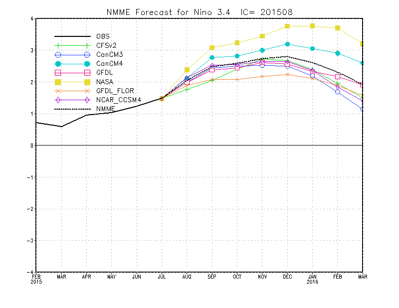
Right now, an “ensemble” consisting of all major national and international climate models suggests a high likelihood that the present El Niño will eventually become the strongest on record, surpassing even 1997-1998 in terms of ocean temperatures in the equatorial Pacific. Even if this event does not become the superlative event in the historical record, it’s virtually certain that it will end up in the top three. Because the atmosphere has responded in a very strong and coherent way to these extremely high ocean temperatures already, there is presently very high confidence that El Niño will persist through the coming autumn and winter months, and continue to strengthen through at least November.
Strongest California winter precipitation signal in years
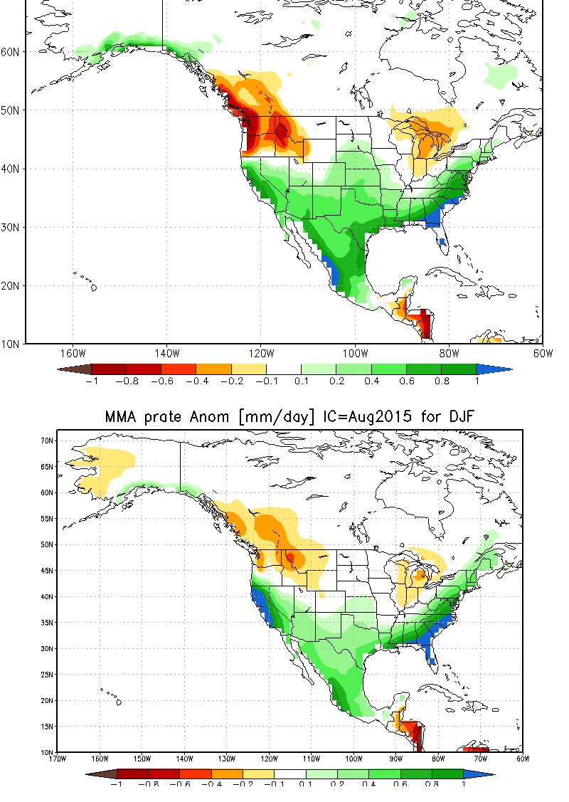
It’s hard to imagine a more powerful predictive signal for California winter precipitation than the occurrence of a very strong El Niño event. Weak to moderate El Niño events can have highly variable effects in California, and are in most cases poor predictors of how much precipitation might fall in the Golden State. But the big events are a whole different ballgame—and the presence of a powerful El Niño in the tropical Pacific is the single most useful piece of information we have regarding what might take place in the months to come.
While even a record-strength El Niño in the tropical Pacific does not mean that California will experience record rains this winter—since there are always other factors at play—it does strongly shift the odds in favor of a wet winter. This not only fits with conceptual models regarding the atmospheric effects of El Niño, but is also strongly supported by model predictions. While the models do disagree upon the details, there is a very clear signal toward a classic “El Niño” winter dipole along the West Coast of North America, with much below-average precipitation in the Pacific Northwest and British Columbia and much above-average precipitation over essentially all of California from the Oregon border to Baja California.
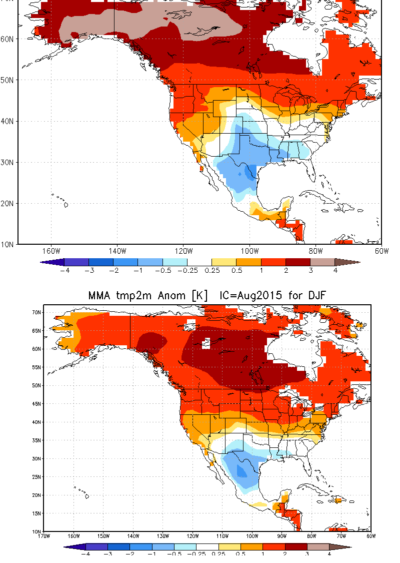
The model ensembles also agree that mean winter temperatures are likely to be warmer than average all up and down the Pacific Coast, which suggests that the elevation of the mean snow line will probably be higher than average yet again this coming winter. This has significant implications for the Pacific Northwest—which stands a good chance of seeing very dry and warm conditions—and for California, which may see quite a lot of water falling from the sky in liquid form but considerably less falling as snow and sticking around to form a substantial middle-elevation snowpack. Despite this, snowpack in many regions was so absurdly low during winter 2014-2015 that even a modest accumulation in 2015-2016 would represent a substantial “improvement” in relative terms.
Death of the Ridiculously Resilient Ridge? Why it’s not really a tale of El Niño vs. “The Blob”
There has been much discussion recently regarding the potentially competing influences of long-distance atmospheric teleconnections from El Niño in the tropical Pacific and effects of the closer-to-home northeastern Pacific “Blob” of warm water off the Washington and Oregon coastlines. It’s certainly true that unusual ocean temperature patterns at both tropical and high-latitude locations can affect atmospheric circulation. And, in the hypothetical case where the persistent region of warm water in the North Pacific associated with “The Blob” stuck around through the winter, it’s plausible that this could modulate the atmospheric effects of the powerful El Niño event in the tropics. But that hypothetical situation is rather unlikely to actually occur this winter. That’s primarily because “The Blob” itself is thought to largely be a side-effect of the multi-year persistence of the Ridiculously Resilient Ridge, which suppressed the North Pacific storm track and prevented the vertical mixing of colder subsurface ocean waters toward the surface.
It’s certainly possible that there has been some degree of self-reinforcement in this situation—where the Triple R triggered The Blob in the first place, but the Triple R was later sustained by it, and so on—but it does not appear that The Blob was the primary cause of the infamous Ridge in the first place. While scientists are still working to determine precisely what confluence of conditions allowed for the Triple R’s extraordinary multi-year persistence—and which may include effects from regions as far away as the Arctic—there is considerable evidence that a fundamental driver of the Triple R’s longevity was the persistent warmth of the western tropical Pacific ocean (mentioned in the first section of this article). And that warmth is rapidly disappearing as El Niño strengthens rapidly. The take-home message here: a primary cause of the Triple R is no longer in place, and so it’s unlikely that we’ll see yet another winter of persistent anomalous ridging over the northeastern Pacific Ocean.
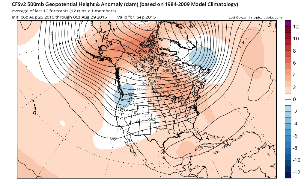
Further evidence comes from ocean-atmosphere model forecasts, which suggest a profound deepening of the Gulf of Alaska low this winter along with a greatly enhanced and southerly-shifted storm track over the Eastern Pacific. Moreover, the warm “Blob” in the North Pacific essentially disappears in model forecasts later this winter, likely a product of numerous storm systems bringing vigorous vertical mixing of the ocean and drawing up cooler water from beneath. In short: the best available evidence suggests that we’re far more likely to witness the development of a Truly Tenacious Trough this winter than a return of the Ridiculously Resilient Ridge.
What about those East Pacific hurricanes?
As I’ve discussed in the past, hurricanes originating in the subtropical east Pacific do sometimes have significant impacts in California during the late summer and fall months—and that likelihood is greatly enhanced during strong El Niño events like the present one. This potential already been realized in the East Pacific, and the “hyperactive” hurricane season in this basin has already set numerous all-time records. As we get closer to autumn, the occurrence of Gulf of Alaska troughs increases, and the potential for a decaying Pacific hurricane to become entrained and re-curve toward California increases as well. Recent weather model forecasts are suggesting that we may have to keep an eye on the central Pacific—not only the east Pacific—for re-curving storms this autumn (which is not something I can recall having happened before). Impacts in California from such an event are typically more of a novelty than anything else, but there are exceptions—including the dramatic events in Southern California associated with the landfalling remnants of former Hurricane Dolores earlier this summer.
The drought paradox: feast AND famine?
Major winter flood events can occur in California in any given year. In fact, some of California’s worst flood events have occurred when the tropical Pacific is in an ENSO-neutral state. However, the present very strong El Niño is expected to substantially strengthen the subtropical jet stream and associated low-latitude storm track near California this winter, which will bring the potential for more frequent and dynamically stronger systems than would typically occur during the December-March period. Further, water temperatures along the immediate Pacific coastline are expected to remain very warm through the coming winter, which will likely increase the amount of lower-atmospheric moisture available to California-bound storm systems (and perhaps also increase near-surface instability). All of this suggests that there could be a substantially increased risk of precipitation-related hazards this winter in California, including flooding and landslides.
Another potentially aggravating factor will be the lingering effects of California’s severe drought. Burn scars from particularly intensely-burning fires in recent years cover hundreds of thousands of acres of the California landscape, and these regions will be profoundly vulnerable to debris flows and landslides as a result of the decreased infiltration capacity of scorched soils. Widespread drought-related tree mortality—both in natural forest stands and also in urban areas—may worsen the impacts of winter storms this year. Drought-killed (or weakened) trees will topple more easily during periods of strong winds, presenting hazards in and of themselves but also increasing the debris load in river and stream channels across the state (and potentially increasing flood risk).
At the same time, California’s multi-year precipitation deficits remain so large (equivalent to 1-2 years’ worth of precipitation on a statewide basis) that it would be essentially impossible to make up the difference in a single year. It’s entirely plausible that many of the state’s major reservoirs will be in substantially better shape after the coming winter, and that short-term drought indicators will improve drastically—which would be very good news, indeed. But it would take an extended sequence of cool, wet winters to meaningfully replenish depleted groundwater aquifers, improve upon the truly abysmal Sierra Nevada snowpack in recent winters, and alleviate some of the long-term ecosystem impacts of California’s ongoing record “hot drought.” Unfortunately, such an outcome doesn’t appear to be in the cards.
Update: Since Oct 2011, California missing 1-2+ years of rain. #cadrought pic.twitter.com/aX9ht0mv0o
— NWS Phoenix (@NWSPhoenix) August 13, 2015
Key Points regarding El Niño and the coming California winter
- A powerful El Niño event in the tropical Pacific is virtually certain, and the present event has a good shot at becoming the strongest on record.
- A wetter and warmer than average winter is likely for most or all of California in 2015-2016, and there may be an increased risk of flooding in many regions.
- Partial and potentially substantial alleviation of drought severity in California is likely, though even the wettest winter on record would be insufficient to erase California’s multi-year water deficits.
- Even though heavy snow may fall at the highest elevations, it’s not clear that conditions will be consistently cold enough for substantial snowpack accumulation at middle elevations in California.
- Record-warm North Pacific brings increased risk that East/Central Pacific hurricane remnants will affect California between now and the end of October.
- Managing hydrological impacts of simultaneously-occurring record El Niño and record drought in California will be challenging.
© 2015 WEATHER WEST
Discover more from Weather West
Subscribe to get the latest posts sent to your email.