Recent weather summary
This section will be very short: the past 2-4 weeks have been extraordinarily warm and dry throughout California, and entirely uncharacteristic of late winter.
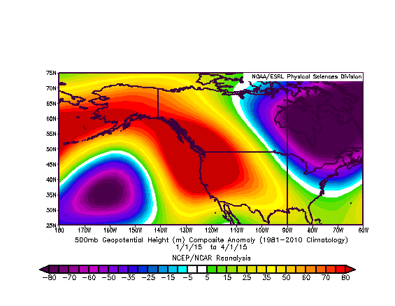
Once again, a persistent region of high pressure (The Ridiculously Resilient Ridge, Redux) has prevailed across the northeastern Pacific Ocean.This anomalous ridge shifted the jet stream and associated storm track well to the north of California, bringing well above-normal temperatures and well below-normal precipitation. Meanwhile, a persistent Arctic airmass brought cold and snow across much of eastern North America on the other side of the conspicuous “North American Winter Dipole” pattern. Sound familiar?
Recent drought evolution
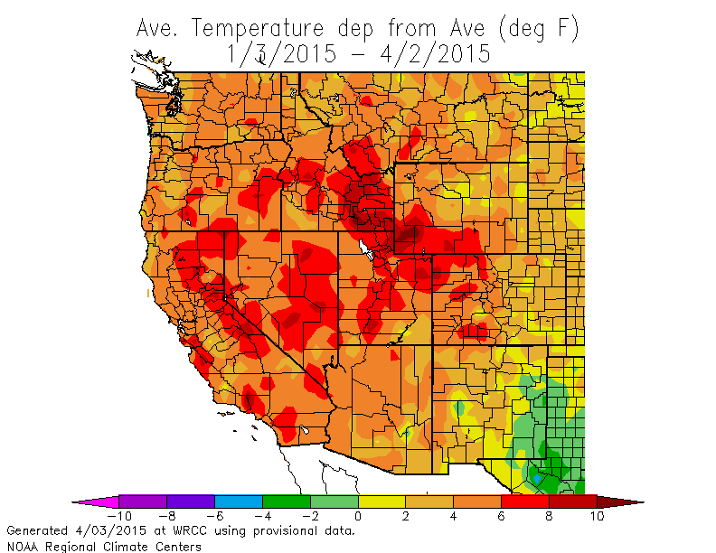
Wide swaths of California have continued to set all-time high temperature and low precipitation records on a variety of timescales. Most readers are already acutely aware that 2014 was California’s warmest year in recorded history, and that Dec-Feb 2013-2014 and Dec-Feb 2014-2015 have consecutively been California’s warmest winter seasons on record. California’s incredible warmth continued during March, and a number of new all-time March maximum temperature records were set in 2015.
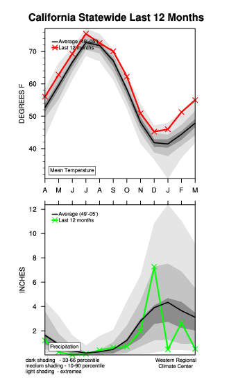
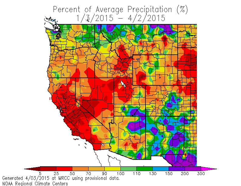
Southern California baked during multiple waves of summer-like heat, with high temperatures approaching 100 degrees in some spots. Also increasingly apparent in recent months is the fact that the Pacific precipitation spigot has once again shut off, and calendar year 2015 is off to a phenomenally dry start across almost all of California. San Francisco, in fact, witnessed its driest January-March period in history. Despite the intense rainfall which occurred during a series of warm “atmospheric river”-related storm events back in December 2014, the Water Year 2014-2015 is now well below average across most of the state–which marks the fourth consecutive low precipitation year in California.
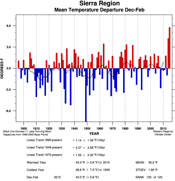
Nowhere have the combined effects of extremely low precipitation and extremely high temperatures been more pronounced than in California’s Sierra Nevada. On April 1st it was announced–with considerable fanfare–that the California’s mountain snowpack had reached a new all-time record minimum. Particularly remarkable is just how far 2015 falls below all previous low snowpack years (including last winter 2013-2014, and the notable snow drought of 1976-1977) : 2015 set the new record by an astonishing 80% margin. While all of California has been dry and warm over the past few years, the extreme temperature anomalies observed in the Sierra Nevada during winter 2014-2015 have been truly amazing. Many high elevations have been almost continuously above freezing for many weeks this winter, and South Lake Tahoe has approached 70 degrees on multiple occasions already this year.
After some modest improvement in the regional severity of the multi-year drought due to heavy precipitation in NorCal back in December, most drought indicators are creeping back upward as a result of the renewed dryness and warmth–and on a statewide basis, aggregate drought metrics continue to worsen in the long term.
In response to the record-low snowpack and persistence of warm/dry conditions, California Governor Jerry Brown announced California’s first-ever mandatory statewide urban water restrictions earlier this week. Regional and national fire agencies have begun to highlight their expectation that summer/fall 2015 will likely feature exceptionally high wildfire risk across much of California, especially in higher-elevation forests and in areas that are now experiencing elevated tree mortality due to drought stress and bark beetle infestations.
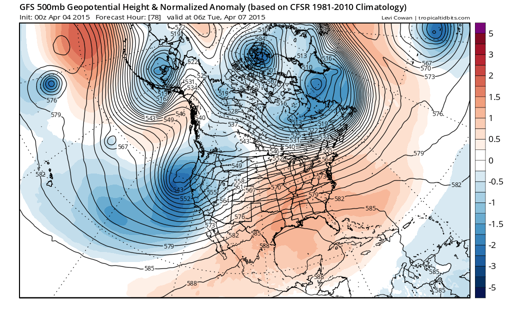
But…a major pattern change is imminent: wetter/cooler weather on the way!
Believe it or not, wet and cool conditions are on the way to much of California later this weekend. A series of systems–originating, at last, from the Gulf of Alaska–will bring much-welcomed late season rain and snow to most of California at times over the next 5 days.
Significant precipitation is possible in NorCal, where as much as 1-3 inches could fall in the wettest spots over the next week (with perhaps a widespread inch or so as far south as San Francisco and Sacramento). Gusty winds will be possible along the coast ahead of the main cold front on Wednesday, though they shouldn’t be strong enough to cause many problems. Even more notably, snow levels will be rather low with these incoming cold storms–likely down below 3500 feet at times in the north, perhaps as low as 2000-2500 feet in the far north. A handful of spots in the Sierra Nevada foothills may actually see a better shot of accumulating snowfall with the systems this week (i.e. in April) than at any other point this winter! Near or slightly below-average temperatures will feel particularly cold this week by comparison to the incredibly warm winter we just experienced, so this incoming pattern change will be quite noticeable for most folks. Some relatively light rain and cooler conditions will make it down to SoCal, though the majority of the precipitation will stay north of Santa Barbara.
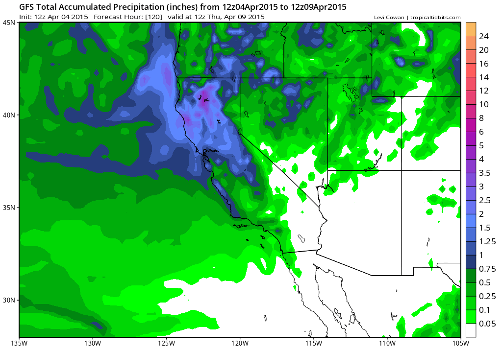
In addition to the blustery and wet conditions, scattered thunderstorms (and associated hail) are likely to occur at least in some spots from Sunday into early next week, potentially throwing some exciting weather into the mix. In fact, there may be at least a modest risk of some severe thunderstorms on Tuesday afternoon in the Central Valley, particularly if the cold front moves through early enough in the day to allow for substantial surface heating in the strong early spring sun.
There are some inconsistent signals in the long-range models regarding how long this pattern change will last. There were indications a couple of days ago that we might be headed for at least a 1-2 week period of active weather and precipitation in California, though it now appears more likely that incoming systems after the Monday/Tuesday one may split apart before making it to the coast. Still: it does appear–at least for the time being–that we’ll see a reprieve from the RRR(R).
A brief thought about the really long range
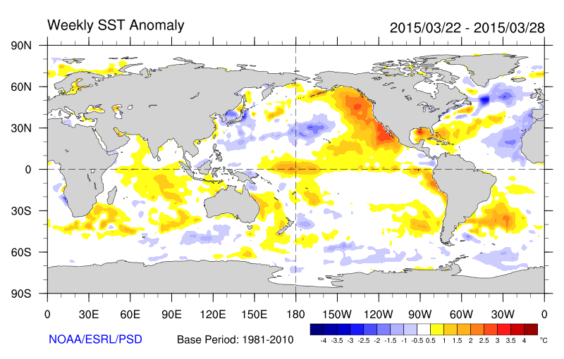
There are increasingly prominent indications–both from observations of the tropical Pacific Ocean and atmosphere and from dynamical model simulations–that the world may be headed for well-defined, perhaps strong El Niño conditions later this summer and into the fall. However, we’ve heard this before: last year, in fact, there were very similar indications of a strong El Niño event in the works, and only a very modest, atypical event actually ended up taking place. The failure of most dynamical ocean-atmosphere models to capture this recent evolution means that it is probably wise to view these renewed ENSO forecasts with some modest skepticism, though it’s worth noting that 2015 has already featured a westerly wind burst even stronger than last year’s very impressive one, and that warm conditions have started to develop rather rapidly across the tropical East Pacific in recent weeks (and have been in place in the Central Pacific all winter). It is, of course, important to remember that even a strong El Niño event does not guarantee a wet winter in California, and that California would need to see multiple very wet winters to fully recover from its exceptional, record-breaking drought. Nevertheless, I’ll be following developments in the tropical Pacific very closely over the coming months. Stay tuned!
© 2015 WEATHER WEST
Discover more from Weather West
Subscribe to get the latest posts sent to your email.