Summary of recent conditions
Well, it has certainly been warm out there. Record warmth, in fact, has occurred on most days so far this calendar year somewhere in the state of California.
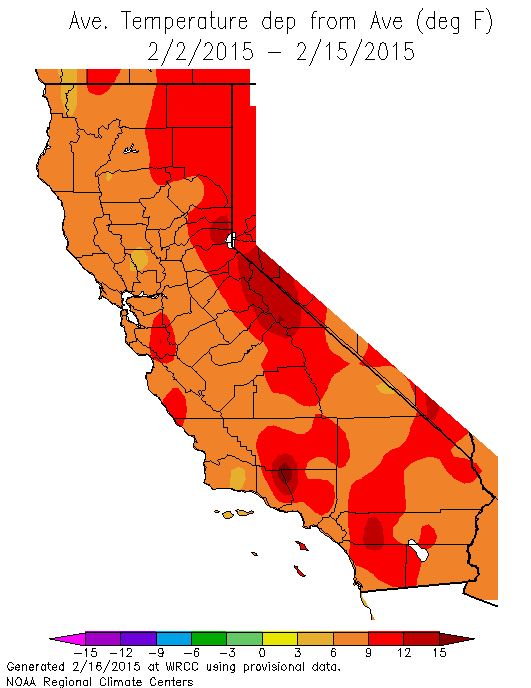
A veritable February heatwave occurred over the recent holiday weekend, bringing record highs from the Mexican border all the way up to Oregon. And the calendar year to date, in some spots (including San Francisco), is currently the warmest on record. 2015 thus far is certainly among the warmest calendar years to date on a statewide basis, and will likely surpass (by the end of February) the previous record…set just last year (in 2014). This extraordinary warmth has been especially pronounced over the past 10 days as clear skies and shirtsleeve weather allowed many Californians to get outdoors and enjoy the strangely balmy February conditions. But those spending time outdoors over the past weekend have likely noticed signs that the present situation is far from typical for mid-winter in California. Vegetation–native and otherwise–has already begun to show signs of growth and flowering that typically aren’t experienced until well into the spring. Despite the green hillsides, streamflow in most of California’s creeks, streams, and rivers remains well below average for this time of year. Sierra Nevada snowpack–already at near-record low levels before the mid-February heatwave which brought temperatures above 60 degrees to the Tahoe Basin–has declined even further in recent days.
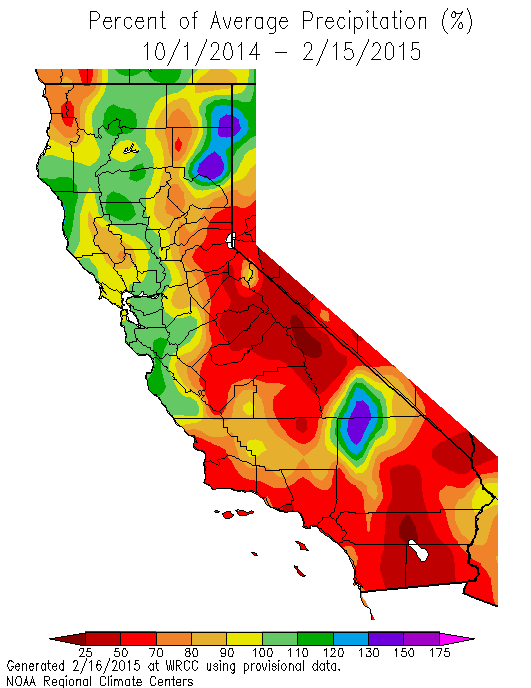
Early in the month, a very brief sequence of strong and moist storm systems brought widespread significant precipitation to the northern 2/3 of the state, with a focus on northern coastal areas. This intense rainfall did result in rapid rises on certain rivers in NorCal, and resulted in temporarily strong inflows into many of NorCal’s major reservoirs. Remarkably, however, this storm sequence ultimately resulted in little or no lasting snow accumulation below 8000 feet in the Sierra Nevada. Extremely warm temperatures dominated the event–not surprising, given the subtropical origin of the moisture. Interestingly, this event was quite similar to the brief but intense warm and wet storm sequence experienced in NorCal back in December 2014.
The Ridiculously Resilient Ridge has returned…with a twist
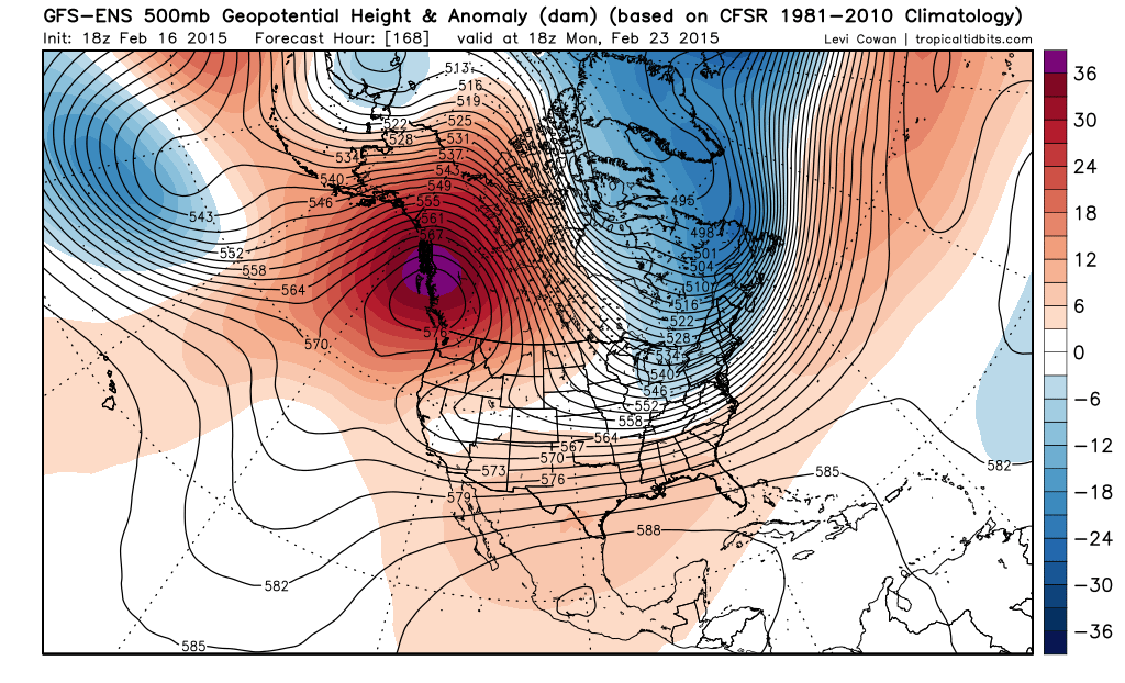
Over the past year, I’ve received numerous questions regarding the purported re-appearance of the Triple R. Typically, my answer has been that the Ridge had not returned, since according to its original definition in 2013, the anomalous high pressure needed to persist across multi-month averages to technically qualify. That longevity–that incredible persistence over months–was what made the atmospheric feature so remarkable in the first place.
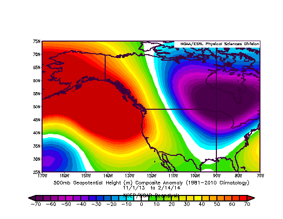
Well, folks, we’ve now reached that point once again: a distinctly positive geopotential height anomaly is now present in 2-3 month averages across the far northeastern Pacific and West Coast, signaling that the Ridiculously Resilient Ridge has indeed returned.
The overall situation, however, is a bit different this year. While 2013-2014 brought the lowest calendar year and 12-month precipitation on record to the state of California, 2014-2015 is trending quite a bit wetter on a statewide basis. This is particularly true in the north, where some spots are currently hovering right around average for the water year to date. Amazingly, this has occurred despite the fact that some of the same regions in NorCal have been setting records for their driest Januaries/longest mid-winter dry spells. Most of the precipitation that has fallen in NorCal this winter has occurred as the result of the two brief, warm, and intense storm sequences in early December and early February. In fact, in a few spots around the Bay Area, the vast majority of the precipitation so far this winter has occurred over the course of just 3-4 calendar days (!). Together, these data suggest a remarkable temporal concentration (intensification) of precipitation in California this winter.
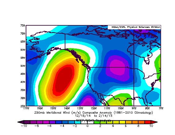
There is a common cause of the extreme warmth, record-setting precipitation variability, and exceptionally low Sierra Nevada snowpack: the Ridiculously Resilient Ridge, Redux. This persistent feature near the West Coast has set up a little further east this year than in preceding winters, allowing the subtropical jet to make occasional incursions along its western flank. As this persistent ridge has wobbled around, conditions have remained very warm during both wet and dry spells. In addition, the Western ridge is forcing Pacific storm systems to take make a sharp poleward turn 1000-2000 miles west of California, advecting copious warm/moist subtropical air toward much higher latitudes in Alaska and British Columbia. Because the ridge is slightly further east this winter, California has been able to benefit very occasionally from this constant northward stream of moisture–meaning that what precipitation has occurred has been of the warm and wet variety.
In this sense, the Triple R of 2014-2015 is notably different from 2013-2014. California has certainly received more precipitation this year on a liquid equivalent basis, though we’re once again falling rapidly behind average as February turns out to be mostly dry. The extreme warmth and low snowpack, however, are very reminiscent of recent winters–as is the occurrence of infrequent but intense warm storms. It’s interesting to note that nearly the entire western United States has been exceptionally warm in recent months, while the eastern part of the country remains locked in a recurring nightmare of extreme Arctic outbreaks and almost inconceivable snow accumulations in parts of New England. This overall setup–with a big Western ridge and a deep Eastern trough–has become known as the “Warm West/Cool East” dipole pattern, and it has been a common feature of recent winters in North America. There are a number of hypotheses currently being investigated regarding the causes of an apparent recent increase in the occurrence of this pattern, though there’s not yet compelling evidence pointing to a singular cause (that’s a topic for a future blog post!).
What is more certain, at least as far as California is concerned, is that our severe long-term drought is unlikely to improve substantially until this newly-invigorated pattern of persistent West Coast high pressure is no longer dominant.
Medium-term outlook
Unfortunately, the large-scale pattern appears to be locked in place for at least another 10 days, which brings us close to the end of February.
While certain model solutions are indicating that a “Rex” blocking setup could evolve–with some sort of weak low pressure near Southern California potentially generating showers over the mountains–prospects for a breakthrough of the Pacific jet (and a return of widespread, meaningful precipitation) appear slim. It is possible, however, that such a pattern would be less anomalously warm than the absurd mid-winter heat California has recently been experiencing. The dynamical models–which historically have had a tendency to break down blocking ridges too quickly due to numerical instabilities–have been consistently underestimating the longevity of the present ridging event (just like they did in 2014 and 2013). Thus, it’s hard to say when the next big pattern change will occur…except to say that it’s very unlikely to happen in the next 7-10 days. Stay tuned!
© 2015 WEATHER WEST
Discover more from Weather West
Subscribe to get the latest posts sent to your email.