Recent Weather Summary

Precipitation during the first few days of the month was so significant, however, that despite an ongoing short-term dry spell, December 2014 will still go down in the record books as among the wettest in history in the Bay Area and Sacramento regions. In fact, across much of the state, precipitation for the water year to date is actually above average–in some spots, 130-150% of average or more. The impressive precipitation events during early December brought a considerable amount of water to extreme drought-stricken California, and has been highly effective in alleviating short-term drought impacts like enhanced wildfire risk, low streamflows, and ecosystem stresses.
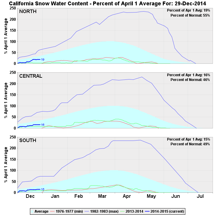
Record-warm sea surface temperatures along the California coast likely contributed to some of the very intense downpours observed in the Bay Area and along the Central Coast, but also raised snow levels in the Sierra Nevada well above pass levels, and snow accumulations below 8000 feet were rather insubstantial. Additionally, much of the moisture from these systems “precipitated out” before reaching some of California’s more interior watersheds, and Sierra water year liquid equivalent precipitation to date is actually below average. When it comes to snow water equivalent, the situation looks even worse–overall, the California’s snowpack is currently around half of average to date (and falling rapidly during the present dry spell). 2014 is now expected–with essentially 100% certainty–to go down in history as California’s warmest year on record, and probably by a very wide margin (I’ll have a separate post on California’s record warmth in the midst of an exceptional drought in early 2015).
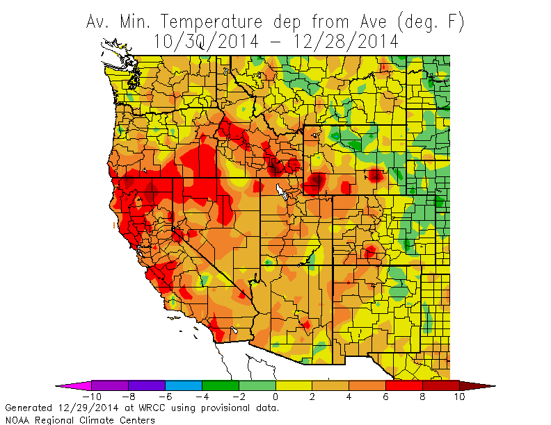
Particularly remarkable in recent weeks are the departures from average of overnight minimum temperatures. Across nearly all of California (and, indeed, most of the American West), minimum temperature have averaged anywhere from 6 to 15 F above average. Across large parts of California, this means that nighttime temperatures in mid-December have been hovering near the average daytime highs for this time of year.
Given the drought-stressed nature of vegetation in this region, significant tree damage and power outages may be possible as this cold, dry, and windy system moves through. Since the winds with the early December system “underperformed” in many areas, it’s actually possible that the New Year’s wind event will be the strongest in a year or more. Windchills could actually be quite low over the next few days, and will likely drop into the 20s and 30s at times even in the Bay Area and Sacramento region. Actual temperatures won’t drop to record-low levels, but given the extreme overnight warmth in recent weeks, sub-freezing temperature will seem particularly cold by comparison.
In Southern California, the above-mentioned strong winds and cold conditions will combine with slightly more moisture to make for a more interesting forecast. While there is still a lot of uncertainty regarding exactly how far the approaching low will dig (and a difference of even 50-100 miles could make a substantial difference in the eventual outcome), the possibility exists for some very rare low elevation snowfall on New Year’s Day south of Los Angeles. In fact, snow could fall near 1000 feet near the San Diego County coastline. This means that populated inland valleys and desert regions may wake up to a dusting (or more) of the white stuff in the new year. It’s even possible that the Las Vegas Strip will see some accumulating snowfall by the morning of January 1st! As is always the case with this kind of system, it’s possible that there could be a few surprises–including either snow at elevations even under 1000 feet or alternately the total absence of precipitation (and thus snowfall) anywhere in Southern California. Precipitation is expected to remain light in any event, so this event is likely to be more of a novelty than anything else. Still: snow under 2000 feet in Southern California is very unusual, and it could make for very picturesque morning in at least a handful of locations not accustomed to such conditions.
© 2014/2015 WEATHER WEST
