Recent Weather Summary
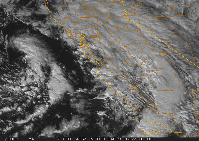
Over the past few days most of California has experienced an atmospheric phenomenon not experienced in quite some time: measurable rain and snow has fallen across much of the state for the first time since early December. Two systems have moved through the state over the past week–the first dropped significant precipitation primarily in the Sierra foothills, and the second (and ongoing) system is currently bringing cold showers to California’s coastal regions. Between these two systems, the incredible zero-rain spell across nearly the entire state has finally been broken. While runoff into rivers and streams from these two events has been essentially nonexistent (due to record-low antecedent soil moisture and the relatively light nature of the precipitation), the observed rainfall has drastically lowered the risk of wildfire (and San Joaquin Valley dust storms) in the short term. In a rather dramatic contrast to the all-time record warmth measured in recent weeks, accumulating snowfall has been reported today below 2000 feet in parts of Northern California.
Ridiculously Resilient Ridge shatters January records: part of a global pattern of extremes
January 2014 will probably go down in the record books as the warmest and driest in California history. This is certainly the case for many of California’s major cities–San Francisco, for example, exceeded its previous driest January by 77%, and Sacramento surpassed its previous all-time January high temperature by a full 5 degrees. Many places also exceeded their previous all-time record for consecutive dry days during the “rainy season.” Our all-too-familiar Ridiculously Resilient Ridge dominated the weather throughout January, resulting in an extremely anomalous atmospheric flow pattern that redirected the Pacific storm track well to the north into Southeast Alaska (with some pretty spectacular results).
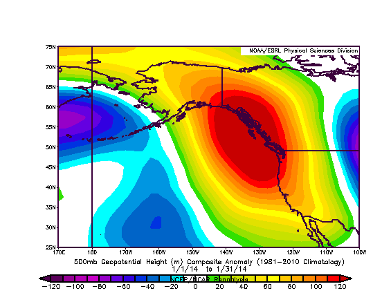
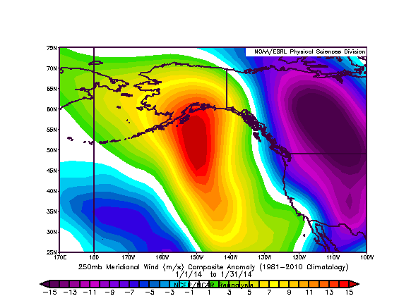
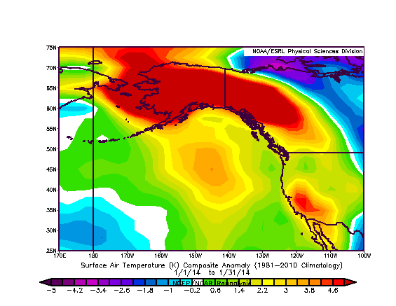
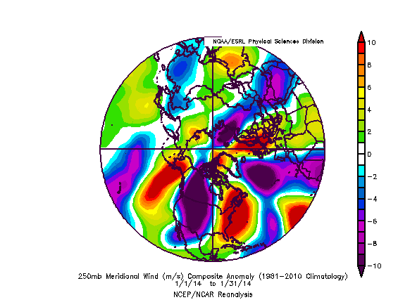
The figures on the left depict some of the most remarkable aspects of the RRR in January, including the massive region of above-normal temperatures extending from the Central Pacific in the west, the Alaskan Arctic in the north, the Front Range of the Rocky Mountains in the east, and the subtropical Pacific Ocean nearly as far south as the Hawaiian Islands to the south. Observing a spatially and temporally coherent region of temperature anomalies over a geographical region this vast is exceptionally rare. Meridional (latitudinal) wind anomalies over this same region clearly show how this extreme wind flow pattern led to these incredible temperature and precipitation anomalies, with very strong poleward (south-to-north) flow to the west of the RRR over the Central Pacific and very strong equatorward (north to south) flow well to the east over the Rocky Mountains. Typically, the region under anomalous north-to-south flow over the Rocky Mountain states would have experienced unusually cold conditions, but the air being advected into the high Arctic over the Pacific was so warm that the return flow lost much of its Arctic punch.
The same cannot be said for the eastern U.S., which has been suffering from very cold conditions and frozen precipitation in some very unusual places. Not to be outdone, the U.K. experienced its wettest January on record in many areas and parts of central and eastern Europe are struggling through massive snowfalls. This rather spectacular chain of extreme weather events across much of the Northern Hemisphere is part of a striking wave-like pattern of large-scale atmospheric anomalies, which has allowed adjacent regions of exceptional cold and exceptional warmth (not to mention record-breaking heavy precipitation and record-breaking drought) to persist for a prolonged period of time. This sort of extremely amplified, highly meridional (north-south oriented) structure has occurred frequently during winter over the past decade, and an increasing body of evidence suggests that such patterns may be linked to the observed rapid decline of Arctic sea ice.
Short-term prospects for California precipitation increase
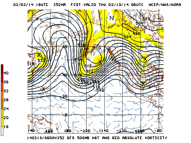
There is some good news to share with fellow thirsty Californians this evening: it does appear that some more rain (and mountain snow) is on the way later this week. The RRR has weakened considerably over the past week and is not currently the formidable obstacle it was in January, seemingly impervious to the effects of Central Pacific storm systems and incursions of the Pacific jet. Now, a much-weakened ridge over the far eastern Pacific will allow a couple of weak systems to brush the state during the upcoming 5-7 days, bringing much cooler temperatures and possibly an additional chance for mid-week showers. There is some uncertainty regarding just how cold it may get this week: the ECMWF and a few GFS ensemble members bring some very cold air to the state, while other model solutions are more moderate.
After that, however, all eyes turn toward the subtropical Pacific. By next weekend, there is substantial model agreement that a plume of enhanced atmospheric water vapor (perhaps even an atmospheric river) will be entrained within a temporarily strengthened subtropical jet over the Eastern Pacific. This moist plume will have the potential to bring significant, perhaps even heavy precipitation to some section of the West Coast next weekend into early next week. Recent runs of the GFS and ECMWF have centered this moisture plume on far northern California, which would bring extremely beneficial rains on the order of inches to the far northern watersheds, though totals would be much less impressive from the Bay Area southward. Some model runs have shifted this moisture plume a few hundred miles further north, however, into Oregon and Washington (with NorCal receiving only modest, mostly orographic precipitation next weekend). The most recent run of the GFS falls into this latter camp, bringing fairly unimpressive precipitation totals to California during the upcoming event. This situation is reminiscent of one that often occurs in late fall, when the Pacific storm track is just beginning to make incursions further south but shortwave ridging near California pushes extremely moist subtropical moisture plumes to the north.
Whether or not California receives significant precipitation next weekend (and perhaps beyond) hinges upon the exact latitude where this moist plume makes landfall, and it might be a couple more days before we get a clearer picture of this expected pattern evolution. And what of our dear friend, the RRR? Well, this region of exceptionally persistent ridging has waxed and waned considerably during its reign this winter and last, and its position has shifted back and forth from the Central Pacific to the West Coast. Long-range model projections suggest that RRR is not dead, but rather that it will re-form fairly far to our west–just south of the Aleutian Islands. This means that a persistent trough may form downstream (to the east), which would be a marked change in the flow pattern observed over the past few months. However, the RRR’s continued existence (albeit at a much greater distance) means two things.
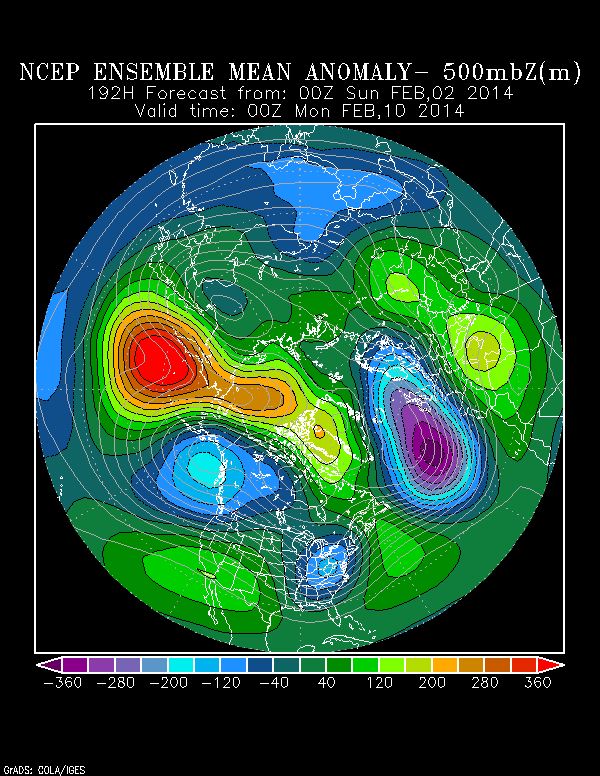
First, California may actually reside in a region of downstream (shortwave) ridging, which could mean that most storms continue to be directed to our north along a storm track into Washington and Oregon. Second, the extraordinary ridging projected to develop over the Central Pacific over the next couple of weeks (i.e. the RRR reincarnated) may still prevent a true extension of the East Asian jet over the Pacific, which not favorable for the development of a much-needed very wet pattern in California.
Still, this is a much more promising pattern for at least occasional precipitation than California has experienced in a long time, and each fraction of an inch that does eventually fall is desperately needed. I am cautiously optimistic that precipitation over the next week or so will at least prevent the long-term deficit from deepening further, though I’m less confident that it will provide any meaningful long-term drought relief.
Just how much rain and snow do we need?
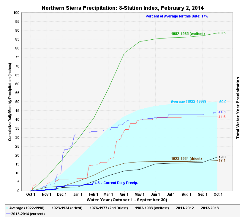
The incredibly dry conditions brought about by the RRR mean that much of the San Francisco Bay Area has been drier than Death Valley over the past six months or so–and perhaps even drier than parts of the northern Sahara Desert. At a recent press conference detailing the unprecedented measures currently being undertaken in response to California’s exceptional drought, a Department of Water Resources official claimed that California would need to receive heavy precipitation every other day between now and the beginning of May to eliminate the existing precipitation deficit. While that might not be literally true, the fact remains: it would take a long series of prolonged, heavy precipitation events to bring California out of its drought. Even after this week’s precipitation, snow water equivalent and overall accumulated precipitation in the Northern Sierra remain at their lowest levels ever observed to date–a truly remarkable statistic.
It is becoming increasingly clear that at least some towns and cities in California do not have enough drinking water to make it through summer, and emergency contingency plans are being put into place in anticipation of even more water districts running dry as the drought continues. For the first time in history, State Water Project deliveries will not occur south of the Sacramento/San Joaquin Delta this year. It’s hard to say exactly how much rainfall we would need to stave off the worst effects of the drought, but now that 2/3 of the rainy season has already passed, it will be hard reach even a modest level of water security without much-above-normal precipitation for the rest of the canonical wet season. Right now, such a scenario just does not appear to be in the cards. Stay tuned.
© 2014 WEATHER WEST
Discover more from Weather West
Subscribe to get the latest posts sent to your email.